

Duval County
Duval County was known as home to various indigenous cultures thousands of years prior to European contact. One such indigenous group, the Mocama, was Timucuan-speaking, residing among the northern Florida coast. Upon the later arrival of the Europeans, much of Duval County was under the control of one of the most powerful known tribes of the region, the Saturiwa. One of the most interesting things, perhaps, in regards to the county’s history is the fact that remains of some of the oldest pottery in U.S. history has been excavated within Jacksonville’s Timucuan Ecological and Historic Preserve. It is believed that these findings date back to 2500 BC. During the 16th century, the French colony of Fort Caroline was established, spiking increased European settlement into the 18th century in Cowford, which is present-day Jacksonville.
In 1822, Duval County was formed out of St. Johns County, named for William Pope Duval. Upon official formation, Duval County covered a large territory from east (Atlantic Ocean) to west (Suwannee River), just north from Suwannee’s mouth to Jacksonville along the St. Johns. Duval then birthed the counties of Nassau and Alachua in 1824 and Clay County in 1858. The portions south and east of the lower St. Johns was given over to Duval County in the 1840’s.
Demographics:
- Seventh most populous county in Florida.
- 918 square miles: 762 square miles of land & 156 square miles of waters.
- 45h & 5th congressional districts.
- Population: 975,961.
- Named for William Pope Duval.
- Founded in 1822.
- Somewhat conservative leanings.
- Averages 220 days of sunshine a year.
- 1,255.9 people per square mile.
- Median age: 36.4
- Median household income: $58,145.
- 368,668 households.
- 44% of residents are married.
- Home to 93,000 military-connected children.
- Home to 27 military installations covering all branches of service.
Duval County Beaches
This collection of communities lies along the northern half of an unnamed barrier island nicknamed “San Pablo Island”. The Beaches are divided from the main body of JAX by the Atlantic Ocean on the east, the St. Johns River to the north and west to the Intracoastal Waterway, comprising part of JAX’s metro area in Duval County, spilling into northern St. Johns County.
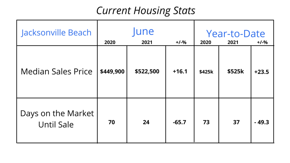
Jacksonville Beach is famous for clubs, bars, restaurants, a vibrant nightlife and a wide range of entertainment options. Perfect for surfing, sandy beach strolls, a visit to the quarter-mile-long Jacksonville Beach Fishing Pier, or dining at one of many waterfront restaurants. Population: 23,399.
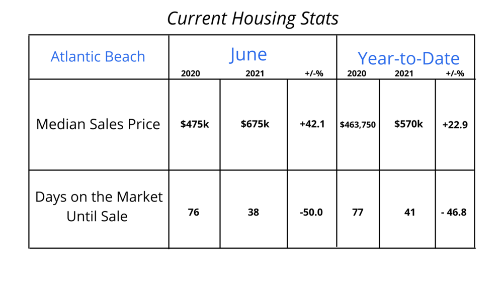
Atlantic Beach is mainly residential, stocked with single-family homes. Just north of Neptune Beach, this is the prime location for biking, surfing, swimming and sunbathing beneath the Florida rays. Population: 13,575.
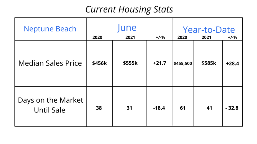
Neptune Beach covers 2.5 square miles between Atlantic Beach & Jacksonville Beach, featuring multiple shopping and dining options. Operates under strict growth management policies. A suburban area with a relaxing vibe and epic sunsets. Population: 7,101.
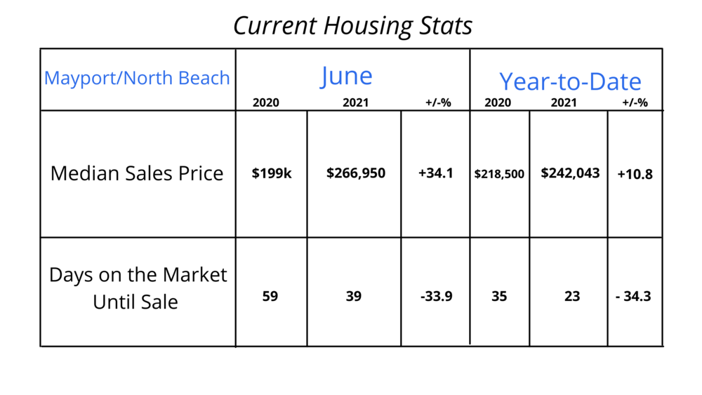
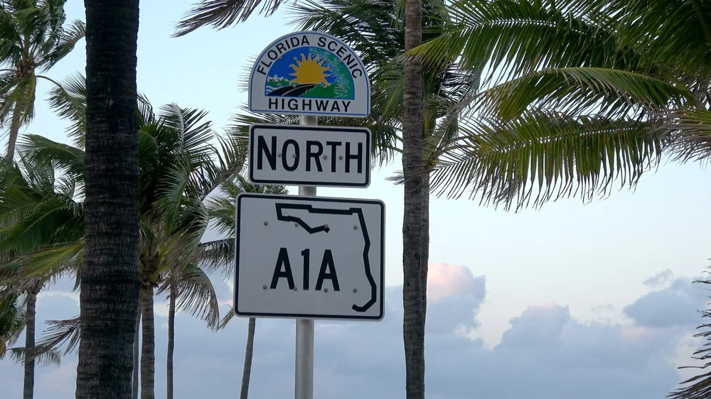
Mayport Beach is the northernmost beach community and is one of the oldest fishing villages in the nation. Famous for shrimp, the St. Johns Ferry and plentiful boat ramps. Mayport offers multiple affordable housing options and is occupied mostly by military personnel employed by Naval Station Mayport, a major U.S. Navy base. The only public road to Mayport is State Road A1A, which crosses the St. Johns River Ferry to Fort George Island.
North Duval County
Demographics
Income:
- Average household income: $74,351.30.
- Median household income: $49,910.00.
- Residents living below the poverty line: 31,867.
- Residents living above the poverty line: 133,886.
Demographics:
- Current population: 170,364.
- 61,972 households.
- 40 is the median age of the population.
- 56,752 residents are married.
- 82,164 residents are single.
- 74.43% of employed residents are white collar.
- 25.57% of employed residents are blue collar.
Getting Around:
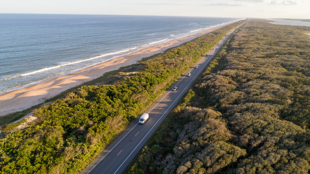
Northside limited access highways consist of I-95 routes north to Washington, D.C. and south to Miami. The I-295 Beltway runs the perimeter of the city, connecting to all interstate highways. Major arterial highways consist of: US 1, US 17, US 23, State Road 115 and State Road A1A which runs along the Atlantic Ocean and is great for those who enjoy a scenic drive.
North Duval County Neighborhoods:
Northside/Oceanway consists of protected ecosystems, cultural landmarks, major logistics/transportation facilities and historic communities. Northside is also home to:
- Jacksonville International Airport.
- Jacksonville Station.
- Jacksonville Zoo & Gardens.
- JAXPORT Cruise Terminal.
- Blount Island Marine Terminal.
- Dames Point Marine Terminal
- Timucuan Ecological and Historic Preserve.
- Machaba Balu Reserve.
- East Coast Greenway.
While there really are no specific boundaries that would constitute the territory of Northside, much of the region lies north of the Urban Core & Westside at 20th Street as well as north and west of the St. Johns. Northside is one of the larger districts in JAX, known for the somewhat brackish Trout River, spanning 20 miles in length and the Ribault River with headwaters elevated seven feet above sea level.
- Black Hammond Island
- Brentwood
- Dinsmore
- Fort George Island
- Garden City
- Highlands
- Lake Forest
- Longbranch
- Moncrief Park
- Norwood
- Panama Park
- Pecan Park
- Oceanway
- Ribault
- Riverview
- Royal Terrace
- San Mateo
- Tallulah-North Shore
Income:
- Average household income: $87.440.76.00.
- Median household income: $60,038.00.
- Residents below poverty line: 24,581.
- Residents above poverty line: 160,549.
Demographics:
- 77,566 households.
- Median age: 36.
- 89,548 residents are single.
- 72,075 residents are married.
- 81.38% of employed residents are white collar & 18.62% are blue collar.
This smaller, vibrant district affords residents outdoor riverfront recreation, historical venues and premium shopping. Southside, a residential and commercial district, offers some of the most spectacular views of the St. John River. With the Intracoastal waterway to the east and Hodges Blvd. is on the west, Southside offers easy access to the John Turner Butler, Beach and Atlantic Boulevards and is home to the popular neighborhoods of Mandarin & San Marco.
- Bustling business center.
- Home to the 1.1 million square-foot St. Johns Town Center. – MOVE THIS INFO TO “SHOPPING”.
- Tinseltown: movie theater, dining, specialty shops, nightlife.
- Jacksonville’s busiest neighborhood.
- 18-minute drive from the beaches via JTB Blvd.
- 71% of residents rent.
- 29% of residents own their homes.
- Largely occupied by young professionals, but features multiple apartments, condos, retirement communities and
- 15-minute commute from Downtown.
- Population: 193,154.
Arlington/Fort Caroline
South of St. Johns River, South Duval County
This suburban district is stocked with hardwood forests, coastal wetlands and generous trails which wind through Jacksonville’s Arboretum & Gardens. Arlington also consists of family restaurants, malls, fast-food joints and the usual big-box stores. Arlington/Fort Caroline architecture is largely mid-century mod with significant contributions from renowned architects such as Robert C. Broward, Taylor Hardwick, and William Morgan. Arlington/Fort Caroline is also home to Crowley Maritime Corporation, an international provider of marine solutions, energy and logistics services. Crowley is the 13th largest private company in Florida, valued at over $2 billion dollars.
Demographics:
- 53% of residents rent.
- 47% of residents own their own home.
- Sparse, suburban feel.
- Family community.
- Covers much of the Timucuan Ecological & Historical Preserve.
- Most lots are 100’ wide.
- Most homes are brick/block.
- Within 30 minutes of easy access to all things JAX.
- Many affordable housing options via waterfront properties, golf communities, condos and single- and multi-family housing.
Geography:
- Population: 5,000.
- Largest section of Jacksonville.
- Borders Southside.
- Connects to beaches, Downtown and Northside.
- Occupies most of Jacksonville east and south of the St. Johns River, north of Southside and the Arlington River and west of the Intracoastal Waterway.
Arlington / Fort Caroline – Getting Around
Arlington’s Regency Area, a center for retail and commercial development, is comparable to the size of Downtown and is full of many corridors bordering SR-113 (Southside Connector: SR115/Southside Blvd., SR-10/Atlantic Blvd., Tredinick Parkway and Regency Square Blvd.). In addition, residents also employ Arlington’s access to East Beltway/I-295.
Jacksonville Transportation Authority utilizes “Route Optimization” in order to provide residents more direct, frequent routing and a high quality of public transportation via bus.
Bus Routes:
- 8 Beach / Town Center
- 9 Arlington / Beach
- 10 Atlantic
- 18 Atlantic / Monument
- 19 Arlington
- 23 Townsend / Southside
- 50 University
- 202 Mayport Express
- 205 Beaches Express
- 308 Arlington Community Shuttles
Mandarin
JAX, South Duval County
Demographics:
- Population: 24, 571.
- 9,785 households.
- Median age: 48.
- 11,969 residents are married.
- 9,020 residents are single.
- 85.57% of employed residents are white collar.
- 14.43% of employed residents are blue collar.
Mandarin, the southernmost neighborhood in JAX, enjoys rich, natural borders consisting of St Johns River on the west, the older neighborhoods of San Jose & Beauclerc on the north and Philips Highway on the east. it offers great shopping, outdoor activities and plentiful historical sites and venues paired with some of the most stunning river views in all of JAX. Mandarin is famous for its magnificent mighty oaks and draping Spanish moss.
Established in the 1760’s by the British, during which time, Francis Levett Sr. developed the 10,000 acre plantation to farm various types of crops. The area was returned to Spain in 1783 via the Treaty of Paris. In 1814, Zephaniah Kinglsey purchased land which he shared with his wife, Anna, who was a slave to him. Anna was an active participant in managing the Kingsley Plantation and earned her freedom in 1811. The Maple Leaf, a Union steamship, sank just off Mandarin point after hitting a Confederate mine in 1864. Many of the Mandarin orange groves froze in the 1890’s and farmers opted out of replanting, selling the land to developers.In 1930, Calvin Reed dubbed the area “Mandarin” as the city was noted for small farms and its export of citrus fruits and vegetables.
Facts:
- Became a part of JAX in 1968.
- Wide selection of housing ranging from condos, single-family homes, brick ramblers and 2-story contemporary houses.
- Former home of Harriet Beecher-Stowe & Lee Adams, famous painter.
- Home to the Mandarin Museum and Walter Jones Historical Park, a 10-acre riverfront site featuring an 1876 farm complex with picnic areas & a citrus grove.
San Marco:
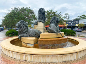
Just west of Philips and east of the St. Johns, San Marco features diverse housing options: bungalows, brick apartment complexes and riverfront mansions. Historic properties are accountable to the San Marco Preservation Society and the community is walkable to distinctive boutiques & art galleries, outdoor cafe dining and emerging trendy craft cocktail bars & breweries. Many residents are less dependent on vehicular transportation and chose to travel about on foot. San Marco’s fountain of lions is reminiscent of Venice’s Italian business district, frequented by visitors who take advantage of free transportation via the Beach Buggy App. San Marco is also home to 14 city parks and 1,000+ new residential units which are either under construction or proposed. A multi-use pathway is planned for the Fuller Warren Bridge, providing a crucial link to highly walkable Riverside.
History
Rich in history, descendants of Isaac Hendricks owned the majority of San Marco in the 1800’s prior to selling off to developers after the Civil War. In fact, one of Hendricks’ homes, constructed in 1854, is still used as a private residence today. The western part of San Marco was once known as a neighborhood called “Oklahoma” and the south side was home to “Alexandria”, a winter home constructed by the Mitchell family.
In 1890, the FEC Railway Bridge was constructed as the first non-boat path crossing the St. Johns with rail access going between South JAX and JAX. The population continued to expand and South Jacksonville was formally established in 1907 and the Acosta Bridge opened to the public in 1921. The whole of San Marco became known as South Jacksonville at the turn of the 20th century. Alexandria was developed into a residential/commercial district in the mid 1920’s by Telfair Stockton.
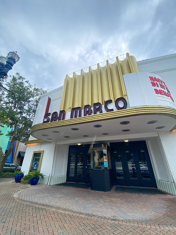
The area was designed to mirror Piazza di San Marco, Italy. The area was then named San Marco and Lake Marco, then a nearby quarry, was born. San Marco Square was constructed in 1927. The 1930’s continued to bring about change as South JAX continued to enjoy commercial and residential expansion and was commonly referred to as San Marco. Baptist Medical Center opened its first hospital in Southbank in the mid 1950’s and plans for Wolfson’s Children’s Hospital were underway. In 1975, the San Marco Preservation Society was established and in the 1980’s, northern San Marco became part of the city’s central business district.
Demographics:
- Population: 35,488.
- 14,500 households.
- Median age: 36.
- 12,170 residents are married.
- 16,190 residents are single.
- 74.67% of employed residents are white collar.
- 25.33% of employed residents are blue collar.
Southside/Baymeadows
South of Arlington, South Duval County
North of St. Johns County, east of U.S. 1 and west of the Intracoastal Community, Southside/Baymeadows offers the largest group of apartment communities in Jacksonville. Southside consists of a large variety of residential housing options with a vast array of single-family homes and gated communities from which to choose. Southside residents enjoy a close proximity to rectreation, shopping, entertainment, Florida Coastal School of Law, the University of North Florida and Jacksonville’s two Florida State College campuses.
Baymeadows is a constantly expanding neighborhood within Southside and surrounds Baymeadows Road. Bay Meadows contains multiple office parks, residential communities and retail centers.
- Population: 12,551.
- Urban/suburban mix.
- Ranked #3 out of 190 for best neighborhoods for young professionals in Jacksonville.
- Ranked #6 out of 190 for best overall neighborhoods to live in Jacksonville.
- Ranked #17 out of 190 as the most diverse neighborhoods in Jacksonville.
- Baymeadows is noted for heavy traffic.
West Duval County
Downtown/Riverfront
Demographics:
- Population: 185,235.
- 68,496 households.
- Median age: 35s.
- 66,345 residents are married.
- 83,608 residents are single.
- 76.36% of employed residents are white collar & 23.64% are blue collar.
- Many residents are military personnel stationed at NAS JAX.
- Additional residents are employed by Cecil Commerce Center.
Income:
- Average household income: $68,842.39.
- Median household income: $50,912.00.
- Residents below poverty level: 27,371.
- Residents above poverty level: 152,457.

With a population of roughly 185,235 residents, heavily wooded Westside is also one of the larger districts of Jacksonville and lies west of the St. Johns River and Downtown at I-95 and south west of Northside. Westside encompasses a large portion of undeveloped land as well as many populated neighborhoods: Argyle, Avondale/Riverside, Cedar Hills, Confederate Point, Lake Shore, Murray Hill, Normandy, Ortega & Sweetwater. It affords young families the opportunity for starter home ownership in a serene, almost country-like setting, however the district is somewhat bikeable as it is in close proximity to Downtown and Springfield. Westside is also home to early 1920’s renovated buildings, representative of the area’s historic roots.
History and Architecture
Home of Naval Air Station Jacksonville and The Blue Angels, boating and fishing enthusiasts are drawn to the convenience of Jacksonville’s water access, partaking of all things outdoors: camping, hiking, fishing, boating, etc. Westside is also home to multiple full-service marinas and boating facilities as well as nautical shops and outfitters.
Westside architecture consists of tudor-style homes, waterfront mansions and 1900’s wooden frame homes. The Buckman Bridge, at three miles in length, crosses the St. Johns River and connects Westside to Mandarin.
- Home to 100-foot, “right-of-way” Cecil Recreational Trails for horseback riders, hikers and off-road cyclists, spanning 14.5 miles from Baldwin to JAX’s Imeson Road.
- Home to Herlong Recreational Airport, offering experiences in skydiving, gliding, light sport aircraft and additional experimental aircraft.
- Home to Jacksonville Equestrian Center, the East coast’s best equestrian center.
- Home to Orange park (south of JAX, west of the St. Johns River), a mecca of water activities, hiking and camping, Boat Florida Rentals, Doctor’s Lake and Black Creek.
- Home to Jacksonville Baldwin Rail Trail, part of the nation-wide “Rails to Trails” program.
Ortega
JAX,West Duval County
South of Riverside, north of Naval Air Station JAX, Ortega lies between the St. Johns and Ortega Rivers. Ortega is considered one of the wealthiest neighborhoods in JAX, consisting of riverfront mansions and historic homes as well as Mediterranean and Tudor Revival style homes. Founded in 1763 after Spain ceded Florida to England. Home to Colonel Daniel McGirtt in 178, who occupied the Jones Plantation while serving with rebel Georgian troops against the Brits. Eventually, he was court martialed by British government and imprisoned at Castillo de San Marco, St. Augustine prior to his escape. In fact, a local road and park in the area are still named after him today. Ortega experienced a construction boom in the 1920’s and has remained a wealthy district full of entrepreneurs and long-time families.
Demographics
- Population: 62,048.
- 23,643 households.
- Median age: 35.
- 20,411 residents are married.
- 30,058 residents are single.
- 73.88% of employed residents are white collar.
- 26.12% of employed residents are blue collar.
- Ortega’s Ortega Forest is a smaller neighborhood with a population of 2,381 offering residents a sparse, urban feel. This community leans conservative.
Riverside/Avondale
JAX, West Duval County
Located southwest of Downtown, along the St. Johns River, adjacent to one another, Riverside & Avondale boast walkable, historic neighborhoods, rich with unique boutiques and fabulous culinary options. Residents enjoy strolling through shaded, tree-lined streets while taking in the historic charm of the King Street District, the Shoppes of Avondale, world-class art at the Cummer Museum of Art & Gardens and the hip, local vibe offered at 5 Points, a mecca of shopping and dining establishments.
Rich in history, Riverside is listed in the National Registry of Historic Places as one of the oldest, most vibrant neighborhoods in JAX. In fact, the unique blend of charm, history and modern innovation have earned Riverside its prestigious status as one of the country’s top 10 neighborhoods. Residents enjoy million dollar waterfront homes amidst urban, community living and upscale apartment buildings.
Avondale Demographics:
- Population: 30,305 – 48.41% are male and 58.59% are female.
- Median Age: 35.
- Total households: 13,020.
- 39.74% of residents have never married.
- 38.18% of residents are married.
- 2.01% of residents are legally separated.
- 5.17% of residents are widowed.
- 16.91% of residents are divorced.
- 80.4% of employed residents are white collar.
- 19.6% of employed residents are blue collar.
- 8.67% of residents are self-employed.
Riverside Demographics:
- Population: 4,434 – 47.5% are male and 52.5% are female.
- Total households: 2,031.
- Median age: 35.
- 42.06% of residents have never married.
- 33.85% of residents are married.
- 2.14% of residents are legally separated.
- 5.72% of residents are widowed.
- 5.72% of residents are divorced.
- 81.58% of employed residents are white collar & 18.42% are blue collar.
- 8.57% of residents are self-employed.
- Average household income: $69,177.83.
- Median household income: $46,012.00.
Welcome to JAX
Duval County
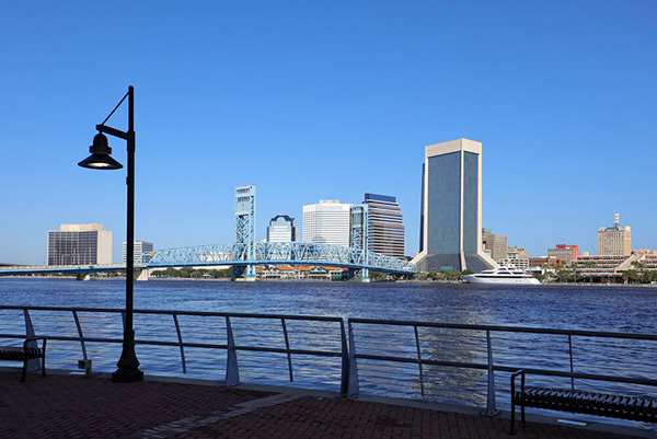
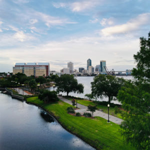
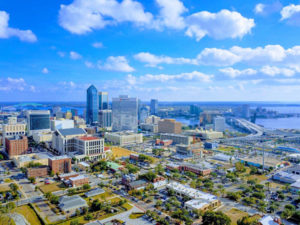
Jacksonville is centered on the banks of the St. Johns River in the First Coast region of northeast Florida, about 25 miles south of Georgia and 328 miles north of Miami. Nicknamed “The River City”, Jacksonville’s strategic location is home to five major bridges which connect the two halves of Duval County:
- Fuller Warren Bridge carries I-95 across the St. Johns River in JAX.
- Acosta Bridge spans the St. Johns River, connecting Downtown JAX’s Southbank and Northbank along State Road 13.
- Main Street Bridge crosses the St. Johns River, carrying four lanes of traffic, signed as US 1/US 90 (SR 5/SR 10).
- The Isaiah David Hart Bridge spans the St. Johns and carries U.S. Route 1 Alternate & State Road 228.
- Mathews Bridge moves traffic along the Arlington Expressway between Downtown and Arlington.
- There are four municipalities just outside of Jacksonville City Limits: Baldwin, Atlantic Beach, Neptune Beach and Jacksonville Beach. Please see the “Beaches” tab for more information.
Jacksonville executes more of a southern vibe than most lower Floridian cities as accents and ambiance are very much of the southern persuasion. In fact, residents would liken Jax to living in Georgia as evidenced by the dreamy, sunshine weather and long, hot summers. Jacksonville hasn’t experienced a snowfall since 1989 and cooler months range from 40-60 degrees.
It’s renowned for:
- 757 miles of land, 116.7 square miles of glorious, sparkling Atlantic water and 22 miles of sandy shoreline, the most shoreline of all U.S. cities..
- 80,000 acres of green space and vibrant, bustling city life.
- Spans 840 square miles and is the 14th largest city in the U.S. with 900,000+ residents.
- Home to the largest urban park system in the U.S.
Jacksonville is typically divided into six sections: Downtown, Arlington, Southside, Westside, Northside and Jacksonville Beaches.
Downtown
Downtown is home to Jacksonville’s central business district and historic section, showcasing the earliest developments in the city. This nucleus is also nestled along the narrowing point of the St. Johns River. Downtown is home to eight major districts: Central Core/Nothbank, Southbank, LaVilla, Brooklyn, The Working Waterfront, The Cathedral and Sports & Entertainment/Stadium/ East Bay and The Historic District. For more information, please see the “JAX Downtown Districts” tab.
LaVilla
LaVilla is predominately African-American neighborhood to the west, just north of Adams street. La Villa is certainly a mecca of African-American culture and is home to the Ritz Theatre, a well-known venue for various African-American performers. LaVilla’s southern neighborhood was formerly a railroad hub and chief red light district for a time.
Brooklyn
Brooklyn is located in the far southwest of the Downtown Core, encompassing the area south of LaVilla and the area north and west of I-95. It’s also connected to Riverside via Riverside Avenue and houses Fidelity National Financial, FIS corporate headquarters, TIAA Bank and additional offices. This neighborhood consists of mixed-use developments, both commercially and residentially zoned.
Central Core/Northbank
Central Core/Northbank is home to government offices, Jacksonville Sheriff’s Office, City Hall, Courthouse, Library, Museum of Contemporary Art and the Riverwalk. Also features the Wells Fargo Center, Bank of America Tower, TIAA Bank Center and the SunTrust Tower.
Southbank
Southbank is a residential/commercial district across from the Northbank, located the St. Johns River on the southern shore, considered as part of the San Marco neighborhood. Home to: the Crowne Plaza Jax Riverfront, Wyndham Jax Riverwalk, the Museum of Science & History, Southbank Riverwalk, Friendship Fountain, the Aetna Building, Riverplace Tower and Baptist Medical Center as well as residential complexes The Peninsula, San Marco Place and The Strand.
The Working Waterfront – where Jacksonville’s water-dependent activity revolving around fishing docks, ports, etc. occurs.
The Cathedral
The Cathedral is near Hogans Creek in the northeast corner, spanning a 36-block, 118-acre radius. Currently undergoing a transformation conducive to living, working, eating, playing, shopping and praying in hopes of attracting a diverse population of residents. This unique area runs north to south from State to Adams Street and east to west from Main to North Liberty Street. This section houses historic churches such as the Mount Zion AME Church, St. John’s Episcopal Cathedral, First Presbyterian Church, Immaculate Conception Catholic Church and the First United Methodist Church as well as former residential structures now serving as offices for many attorneys.
Jax Historic District, known for its pre-1965 architecture post-dating the great fire of 1901, runs from:
Beaver Street to the North.
Liberty & Catherine Streets to the East.
The St. Johns River to the South.
North Pearl Street to the West.
Sports & Entertainment/Stadium/East Bay District – located in the southwest corner of Downtown on East Bay Street. Historically industrial, this unique area is famous for its diverse eateries, bars & breweries, energetic nightlife and fantastic performance venues via “The Elbow”. Sites such as the TIAA Bank Field, VyStar Veterans Memorial Arena, Jacksonville Baseball Grounds, Daily’s Place Amphitheater, Greater Jax Fair/Expo Center and Metro Park are located in this district.
Your Home Sold Guaranteed Realty - Phil Aitken Home Team can help you buy or sell a house in Duval County, Jacksonville, Florida.